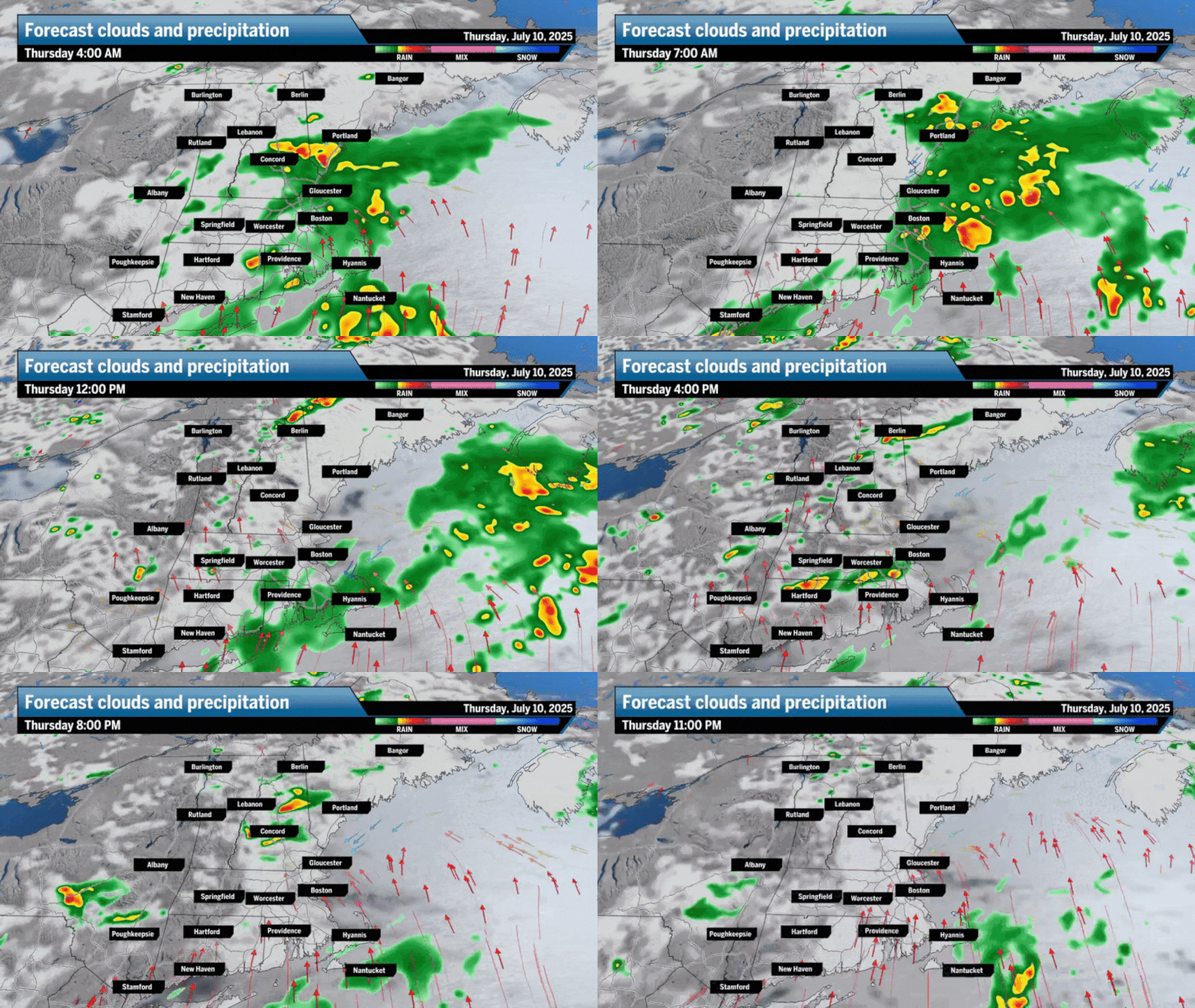
Boston and most of Central and Coastal New England will see early morning rain to start the day, with some downpours mixed in. Temperatures will remain cooler with a dry stretch during the late morning and early afternoon, with highs reaching the 70s. The skies should remain mostly cloudy to overcast throughout the day.
Scattered showers and thunderstorms will pop up and move from west to east throughout the afternoon, with humidity remaining high. Some storms may produce a brief heavy downpour and gusty winds, but the flooding potential remains low.
An isolated shower may lurk Thursday night with lows slipping to the mid-60s.
The setup — two rounds of showers and storms are possible
I’m going to label Thursday as a “storm sandwich” with early morning pockets of showers to heavy rain, a dry midday, and then scattered afternoon showers and thunderstorms popping up across the region. Boston has the best chance of staying dry as storms will fire up across Western New England and push east in the afternoon, drying out a bit as they move between I-495 and I-95. In the morning may see showers and a few rumbles of thunder, so be sure to grab your umbrella.
That stalled frontal boundary is still hanging out west to east across Long Island Sound, allowing for showers to loom over Central and Eastern New England early morning Thursday.
In the afternoon, showers and thunderstorms will spark across Western New England and march eastward fairly quickly. With dew points still in the upper 60s, there will be plenty of juice in the atmosphere for a few gusty winds and heavy downpours with some of these storms.
Shower and thunderstorms will lurk across New England on Thursday.Boston Globe
Temperatures will likely be in the upper 60s when you head out the door with afternoon highs climbing to the low 70s across Boston and the north and south shore, and the mid- to upper 70s west of the coast. A slight sea breeze with mostly cloudy to overcast skies will temper temperatures a bit.
Highs on Thursday will remain cool across New England, mostly in the 70s.Boston GlobeHighs across Southern New England will range mostly in the 70s.Boston Globe
Between the overnight rain and then thunderstorms later in the day, Thursday rainfall totals may range between a quarter of an inch to an inch, with higher totals near Boston and areas south.
Between early morning rain and afternoon storms, rain totals may reach an inch for some across Eastern Southern New England.Boston Globe
There is a low chance for an isolated flash flood with the Thursday storms, with heavy downpours ponding on roadways and low-lying areas.
A marginal risk for flooding is possible across New England on Thursday.Boston Globe
We’ll be dealing with the muggy conditions for the rest of the week, but rain and thunderstorm activity will diminish heading into Friday and the weekend.
Dew points will remain in the upper 60s to low 70s through the start of next week.Boston Globe
Greater Boston: Showers to steady rain in the early morning, followed by a dry stretch. Chance for an afternoon shower or thunderstorm under mostly cloudy skies. Highs to the low 70s thanks to a sea breeze. Lows to the mid-60s with cloudy skies and a shower chance.
Southeastern Mass.: Pockets of steady rain early in the morning, with the region drying out a touch in the late morning and afternoon. Highs to the low 70s near the coast, mid-70s shortly inland under cloudy skies. A chance for an afternoon shower or t-storm is possible. Lows to the mid-60s with a spot shower chance.
Central/Western Mass.: Light morning showers but drying out earlier, around mid-morning. Highs to the mid-70s in Worcester, upper 70s in the Pioneer Valley, and mid-70s again for the Berkshires. Showers and thunderstorms pop up during the afternoon, with an isolated severe storm in the Berkshires to Springfield. Gusty winds will be possible. Mostly cloudy and dry during the night as lows reach the low to mid-60s.
Cape and Islands: Morning showers with a rumble of thunder possible. Some drying in the middle parts of the day. Highs to the low 70s. A chance for an afternoon shower or thunderstorm to pass. Lows in the mid-60s with cloudy skies and a spot shower chance.
Rhode Island: Morning showers loom with a dry stretch midday. Some afternoon showers or thunderstorms are possible, but they’ll be scattered. Highs to the mid-70s under mostly cloudy skies. Dropping to the mid-60s at night with a lingering shower chance.
New Hampshire: Morning showers, especially south of Plymouth. A handful of afternoon showers and thunderstorms are possible across the state. Highs reach the low and mid-70s. Drying out at night with lows to the low 60s under mostly cloudy skies.
Vermont/Maine: Vermont sees a dry start to the day with afternoon showers and thunderstorms possible. Highs to the upper 70s and low 80s with some sun breaking through clouds. Maine sees morning showers with scattered afternoon showers and thunderstorms. Highs reach the low to mid-70s. Lows drop to the low 60s across both states with a low chance for a spot sprinkle, especially over Maine.
Sign up here for our daily Globe Weather Forecast, which will arrive straight into your inbox bright and early each weekday morning.
A look at the weather across Boston for the next seven days.Boston Globe
Ken Mahan can be reached at [email protected]. Follow him on Instagram @kenmahantheweatherman.


