The Storm Prediction Center has placed southern and eastern Indiana under a level 2 of 5 risk for scattered strong to severe storms starting after 3 p.m. today.
INDIANAPOLIS — The Storm Prediction Center has placed southern and eastern Indiana under a level 2 of 5 risk for scattered strong to severe storms starting after 3 p.m. today.
Credit: WTHR
A mainly sunny, humid start with a stormy finish today
We’ll start the weekend with several dry hours as we sit on the warm and humid side of an incoming storm system. Where we see more sunshine across the southern and eastern tiers of the state, temperatures will climb into the low 90s with heat indices of 100-105 degrees.
Credit: WTHR
Scattered strong to severe storm timeline
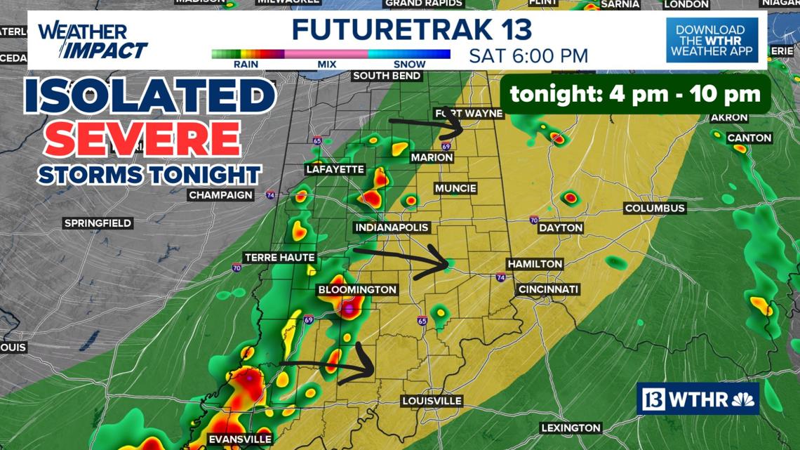
3 p.m.: Storms begin to fire up starting on the western side of the state as the cold front moves in. A few isolated storms are possible in northern Indiana at this time as well.
Credit: WTHR
4 p.m. – 10 p.m.: Storm coverage area increases and will start to push east into the Indy metro between 5 p.m. and 6 p.m.
Credit: WTHR
A few storms could be strong to severe with damaging wind gusts a the primary threat, but brief heavy rainfall could lead to localized areas of flooding. The Storm Prediction Center has placed southern and eastern Indiana under a level 2 of 5 risk.
Credit: WTHR
This line will lose momentum as the sun goes down and the line of storms will taper off after 9 p.m. in eastern Indiana.
Credit: WTHR
Look for partly cloudy skies overnight but still staying rather warm with lows in the low 70s and muggy until the front completely passes through the state and we see a shift in wind direction.
Slightly less humid for Sunday, isolated storm chance south
The boundary will stall out Sunday across the southern part of the state and could prompt a few more scattered storms. This will be most likely mainly south of central Indiana but a stray storm across our southern counties will be possible in the afternoon. We’ll otherwise see partly cloudy skies, highs in the mid to upper 80s, and slightly less muggy conditions with dew points dropping into the mid 60s (as compared to the low 70s today).
Credit: WTHR
Credit: WTHR
Muggy meter climbs again after Monday
Monday will be the exception to a rather unsettled week ahead with daily shower and storm chances. Temperatures heat back into the upper 80s Monday but with lower dew points. The muggy meter again jumps into the “miserable zone” through the week. The most organized rain/storm chances right now look to be Thursday evening into Friday.
Credit: WTHR
Credit: WTHR


